
Lake लेबलों वाले संदेश दिखाए जा रहे हैं. सभी संदेश दिखाएं
Lake लेबलों वाले संदेश दिखाए जा रहे हैं. सभी संदेश दिखाएं


.jpg)

.jpg)
.jpg)

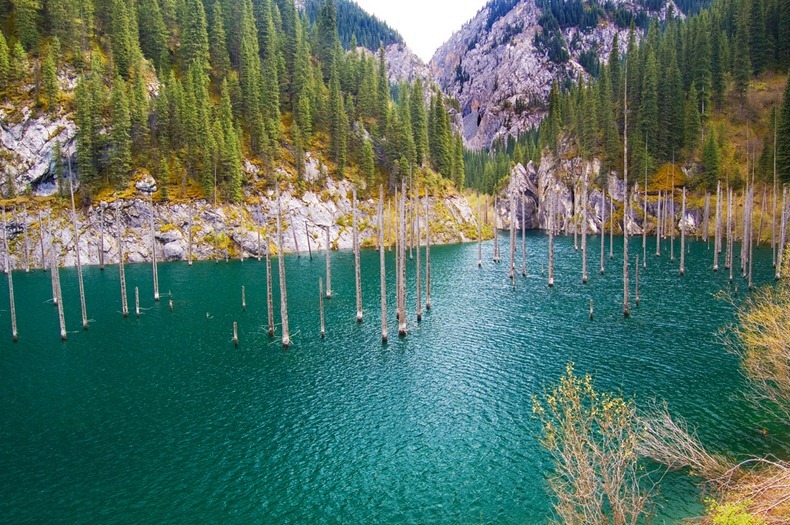
The Sunken Forest of Lake Kaindy
Kaindy Lake is a 400 meter long lake in Kazakhstan’s portion of the Tian Shan Mountains located 129 km from the city of Almaty. The lake was created after an earthquake in 1911 that triggered a large landslide blocking the gorge and forming a natural dam. Subsequently, rainwater filled the valley and created the lake.
The lake is famous for its scenic beauty particularly the submerged forest and the imposing trunks of spruce trees that rises out of the lake water. Above water, the sunken trees appear as large masts from lost ghost ships, or perhaps the spears of a mysterious army hiding and waiting for the right time to emerge.
The water is so cold (even in summer the temperature does not exceed 6 degrees) that the great pines still remain on the trees, even 100 years later. Because of the clear mountain water, you can see deep into the depths of the lake. In winter, the surface of the lake freezes over and during this time, Lake Kaindy becomes a great spot for trout fishing and ice diving.
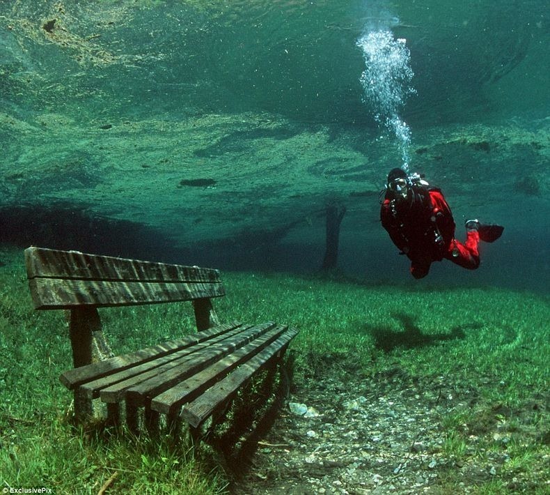
Gruner See, Styria: A Park That Turns Into a Lake in Summer
Grüner See, literally “Green Lake”, is a lake in Styria, Austria, near the town of Tragoss, located at the foot of the snow-capped Hochschwab mountains. During winter, the lake is only 1–2 meter deep and the surrounding area is used as a county park. It is a particular favourite site for hikers. But as the temperature starts rising in spring, the ice and snow on the mountaintops begins to melt and runs down into the basin of land below. The lake swells up to engulf the entire area including the park. During summer, the lake reaches its maximum depth of around 12 meter and is claimed to look the most beautiful at this time.
The lake gets its distinctive green colouring, and the name, from the grass and foliage beneath, and thanks to the fresh snow melt, the ice-cold water is crystal clear clear. The temperature of the lake is rather cold at 4 to 8 °C, yet it’s popular among divers who can observe the green meadows in the edge zone of the lake particularly in June when the water is at its highest. The alpine grasses and flowers of the meadow are visible in full bloom under the water. One can even see benches, a bridge and walking trails.
Starting July, the lake starts to recede and by winter, the lake is back to its original size and the park is returned once more to the hikers.
Crescent Lake in Dunhuang China
Crescent lake also called Yueyaquan in Chinese is a beautiful crescent-shaped lake located 6 km south of the Dunhuang city in the arms of the Echoing-Sand Dune. The Crescent Lake's water is so pure and clear that it looks like an emerald jewel in the sand. Along the side of the Crescent Lake is a pagoda in traditional Han Chinese architecture. A street lined with souvenir stalls leads up from the entrance to the complex. Many tourists ride camels here, organized by the complex operators, to get to the summit of the sand dunes. The lake has been in existence for at least two thousands, but for the last few decades it has been gradually disappearing. According to measurement made in 1960, the average depth of the lake was 4 to 5 meters, with maximum depth 7.5 meters. In the early 1990s, the area of the lake had shrunken to only 1.37-acre (5,500 m2) with average depth of 0.9 meter (maximum 1.3 meter). Crescent Lake has dropped more than 25 feet in the last three decades while the underground water table elsewhere in the area has fallen by as much as 35 feet. In 2006, the local government with help of the central government started to fill the lake and restore its depth; its depth and size have been growing yearly since then.

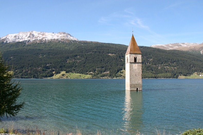
Lake Reschensee and the Drowned Village of Graun
A fourteenth century medieval tower rises out of Lake Reschensee, only a few miles from the Swiss and Austrian borders, in Italy. The steeple of the submerged bell tower is the only visible building of the once thriving village of Graun. In the middle of the last century, the entire town along with 163 homes and the 14th century church had to be sacrificed to make way for a new dam that would increase electricity production.
In 1939, the electric company Montecatini announced plans for a 22-meter deep lake, which would unify two natural lakes - Reschensee and Mittersee - and submerge several villages, including Graun and part of Reschen. Naturally, the locals were none too happy. They fought the flooding tooth and nail but despite the resistance the plan was approved and in 1950 the land was flooded. 523 hectare of cultivated ground and 163 houses were drowned. Lots of families, in spite of the little money the company gave them, had a present with no future. Some moved away, some others tried to build a new life and home in upper Graun, where they still live today.
Crescent Lake in Dunhuang China
Crescent lake also called Yueyaquan in Chinese is a beautiful crescent-shaped lake located 6 km south of the Dunhuang city in the arms of the Echoing-Sand Dune. The Crescent Lake's water is so pure and clear that it looks like an emerald jewel in the sand. Along the side of the Crescent Lake is a pagoda in traditional Han Chinese architecture. A street lined with souvenir stalls leads up from the entrance to the complex. Many tourists ride camels here, organized by the complex operators, to get to the summit of the sand dunes.
The lake has been in existence for at least two thousands, but for the last few decades it has been gradually disappearing. According to measurement made in 1960, the average depth of the lake was 4 to 5 meters, with maximum depth 7.5 meters. In the early 1990s, the area of the lake had shrunken to only 1.37-acre (5,500 m2) with average depth of 0.9 meter (maximum 1.3 meter). Crescent Lake has dropped more than 25 feet in the last three decades while the underground water table elsewhere in the area has fallen by as much as 35 feet.
In 2006, the local government with help of the central government started to fill the lake and restore its depth; its depth and size have been growing yearly since then.
Lake Retba Looks Like a Giant Strawberry Milkshake
Lake Retba or Lac Rose lies north of the Cap Vert peninsula of Senegal, north east of Dakar. Depending on the time of day, the lake changes colour from a light purple to a deep scarlet pink. The unusual colouring of the water is caused by harmless halophilic bacteria that thrive in the lake’s high-salinity environment. The color is particularly visible during the dry season.
"The strawberry colour is produced by salt-loving organism Dunaliella salina. They produce a red pigment that absorbs and uses the energy of sunlight to create more energy, turning the water pink," said Michael Danson, an expert in bacteria from Britain's Bath University.
Covering an area of about 3 sq km, the lake is located about 35km north-east of Senegal’s capital Dakar. Since the 1970s, local residents have been mining Lake Retba for its salt, which they use mainly to preserve fish. Waist-deep in water, the men scrape the bottom of the lake to harvest this universally useful mineral which they collect in baskets in their wooden canoes. The salt is then taken back to shore where it is sectioned into small mounds. Dotted along the lake’s shore, these pristine white hills of salt create an arresting contrast against the pink of the lake. In order to protect their skin from the extreme salinity of the water, the workers rub their skin with shea butter, produced from shea nuts obtained from the Shea nut tree.

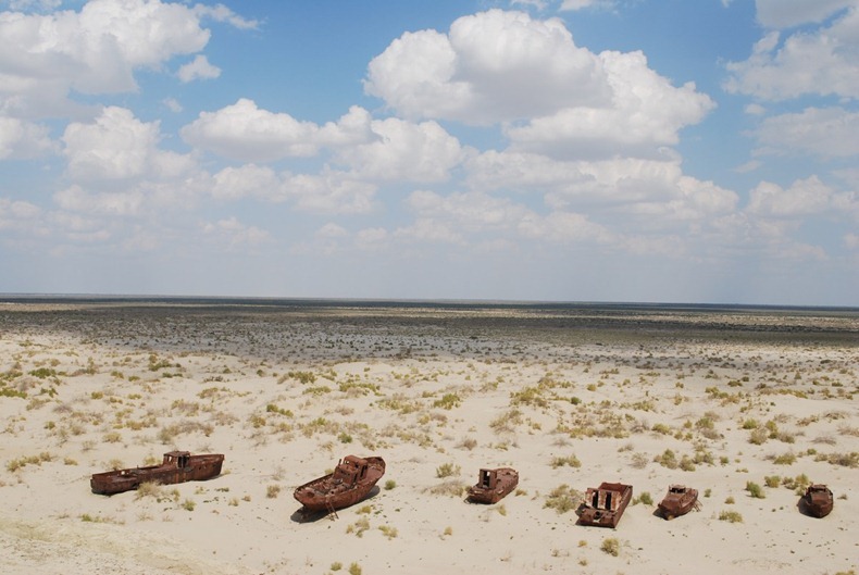
The Disappearing Aral Lake
Moynaq (also spelled as Muynak and Moynaq) is a city in northern Karakalpakstan in western Uzbekistan. Half a century ago, the city was located on the shore of the Aral Sea, a proud fishing community and the largest port in Karakalpakstan’s. In the heydays, Muynak and other towns on the Aral were hauling 160 tons of fish each day from its shimmering waters. Today, Muynak is separated from the sea by more than 150 kilometers. Formerly one of the four largest lakes in the world with an area of 68,000 square kilometres, the Aral Sea has been steadily shrinking. Vessels that once floated in the waters now stand rusting in the sun at the famous ship graveyard. But how did this happen?
In the 1940s, ambitious Soviet planners embarked on a massive water program designed to make the desert bloom. It was decided that the two rivers that fed the Aral Sea, the Amu Darya in the south and the Syr Darya in the northeast, would be diverted to irrigate the desert, in an attempt to grow rice, melons, cereals, and cotton. By 1960, between 20 and 60 cubic kilometres of water were going each year to the land instead of the sea. With most of the sea's water supply gone, the Aral Sea began to shrink. From 1961 to 1970, the Aral's sea level fell at an average of 20 cm a year; in the 1970s, the average rate nearly tripled to 50–60 centimetres per year, and by the 1980s it continued to drop, now with a mean of 80–90 centimetres each year. By 2007, the Aral sea had declined to 10% of its original size.
Most Dangerous Lakes on Earth
A lake is a body of relatively still fresh or salt water of considerable size, localized in a basin, that is surrounded by land apart from a river, stream, or other form of moving water that serves to feed or drain the lake. Lakes are inland and not part of the ocean and therefore are distinct from lagoons, and are larger and deeper than ponds. Lakes are considered as one of the most beautiful part of nature and serves the mankind in many ways. Despite their fascinating beauty, these top 10 dangerous lakes on earth actually hide silent death in their depths...

After being used as a dumping site for radioactive waste for decades, Lake Karachay, located in the southern Ural mountains in western Russia, has become one of the most polluted spot in the world. Spending just five minutes near the lake is enough to receive a deadly radioactive dosis, while spending an hour there will probably kill you within the next few hours. In 1968, during drought conditions, the wind carried radioactive dust away from the lake’s dried area, irradiating half a million people. The radiation was comparable to the effect of the atomic bomb dropped on Hiroshima. Another 7,000 people who lived in the area were relocated.
1. Karachay Lake, Russia

After being used as a dumping site for radioactive waste for decades, Lake Karachay, located in the southern Ural mountains in western Russia, has become one of the most polluted spot in the world. Spending just five minutes near the lake is enough to receive a deadly radioactive dosis, while spending an hour there will probably kill you within the next few hours. In 1968, during drought conditions, the wind carried radioactive dust away from the lake’s dried area, irradiating half a million people. The radiation was comparable to the effect of the atomic bomb dropped on Hiroshima. Another 7,000 people who lived in the area were relocated.
Qiandao Lake: The Thousand Island Lake and Ancient Submerged Cities
Qiandao Lake or the Thousand Island Lake is located in Zhejiang, China, about 150 kilometers from the city of Hangzhou. It is an artificial lake formed after the completion of the Xin'an River hydroelectric station. In 1959, in order to build the Xin'anjiang Reservoir the valley was flooded with water resulting in a lake or reservoir 573 square km in area and with a storage capacity of 17.8 cubic km. The lake is so called because it is dotted with 1,078 large islands and a few thousand smaller ones across it.
Qiandao Lake, known for its clear, and sometimes drinkable water, is used to produce the renowned Nongfu Spring brand of mineral water. It is also home to lush forests (over 90%), and exotic islands. In recent times, it's been turned into a tourist spot with themed islands that include Bird Island, Snake Island, Monkey Island, Lock Island (featuring supposedly the world's biggest lock), and the Island to Remind You of Your Childhood.
But what lies underneath the lake is perhaps more interesting and worthy than the lake itself.
Before the valley was flooded, there stood at the foot of the Wu Shi mountain (Five Lion Mountain) two magnificent ancient cities - Shi Cheng and He Cheng. Shi Cheng was built more than 1300 years ago in 621 AD during the Tang dynasty (AD 618-907) and was once the center of politics, economics and culture. He Cheng is even older: established in 208 AD during the Han dynasty (AD 25 - 200) as a business hub along the Xin'anjiang River.

सदस्यता लें
संदेश (Atom)